v0.2 Released
Atlas Arcana v0.2 is live!
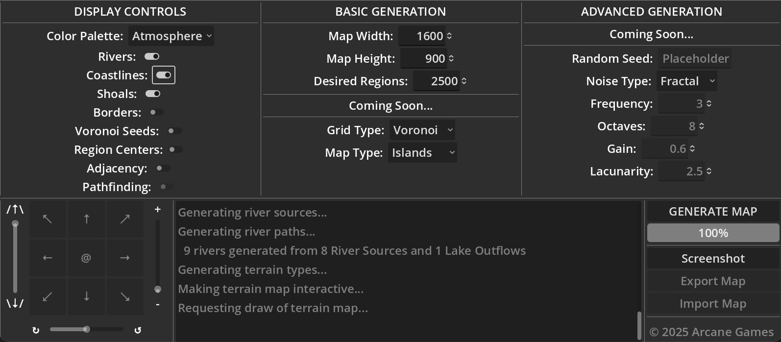
The key focus of this build has been to transition from an initial proof-of-concept to a usable tool. The main user-facing change is the addition of an initial control interface, allowing you to manage various live display options, tweak some basic map generation parameters, and generate maps. Here's the breakdown of what's available:
- Display Controls (changes made here are immediately reflected in the currently displayed map)
- Color Palette (choose from System, Atmosphere, Jewel, Parchment, and Dark)
- Rivers
- Coastlines
- Shoals
- Borders (debug view)
- Voronoi Seeds (debug view)
- Region Centers (debug view)
- Adjacency (debug view)
- Basic Generation (changes made here are reflected when you hit the Generate Map button)
- Map Width (default 1600 px)
- Map Height (default 900 px)
- Desired Regions (default 1200)
- Output Window (Information about the generated map. You can also click on individual regions for region info)
- Generate Map button
- Progress Bar
Behind the scenes, I've made a variety of changes to allow maps to be properly regenerated (as v0.1 reran the application from scratch with each new map) and have been learning a lot about Control Nodes in Godot, how to send signals between nodes, and how to connect everything together into a functioning system.
You'll see a variety of additional controls that aren't properly hooked up yet, including a whole suite of camera controls and advanced inputs into the generation process. And yes, it looks like my fancy unicode icons aren't rendering properly for the web-based version, so that's something I'll look into further when I implement the camera.
If you spot any bugs or if anything jumps out at you as a top priority, let me know - otherwise I'll chip away at some of the low-hanging fruit on my ToDo list.
Atlas Arcana
the magical 2D map generator
| Status | Released |
| Category | Tool |
| Author | Arcane Games |
| Tags | 2D, Backgrounds, Generator, Godot, Indie, Level Editor, PNG, Procedural Generation, Project template, Vector |
More posts
- Atlas Arcana v1.0 is live (and what's next...)Mar 01, 2025
- v0.4 adds screenshots and exportsFeb 09, 2025
- v0.3 adds new map types and grid typesFeb 01, 2025
- v0.2.1 Hotfix releasedJan 30, 2025
Leave a comment
Log in with itch.io to leave a comment.